
KLASS-UAVE

Prion Mk3 is a large fixed-wing UAV with a flight endurance capability up to 1000 km/12 hours and the payload carrying capability up to 15 kg. Payloads can be different types of equipment for geophysical, meteorological, LiDAR surveying, photogrammetry, humanitarian aid, inspections, wildlife counting and many other applications.
Why Prion Mk3?
- Up to 15 kg of payload weight
- Large, flexible space inside
- Easily removable lid allows quick access to payload
- The airframe is weather proof, providing safe and dry area for any type of payload
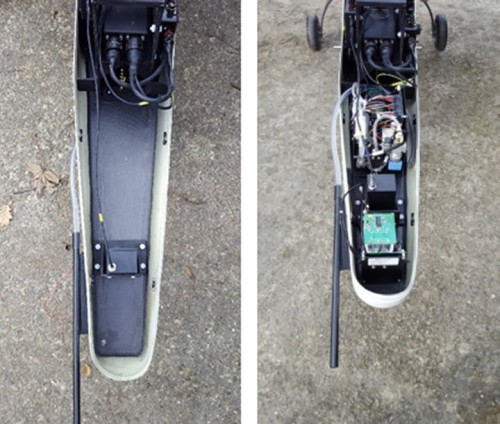 I
I
nside fuselage space of Prion Mk3 with and without the payload. Easily removable lid allows quick access to payload and equipment
47.7l Payload Space
Payload Capacity
- Area 1: (under COG) is approx. 18.1L
- Area 2: (nose) is approx. 29.6L
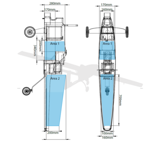
Payload Areas on Prion Mk3. Total payload volume 47,7 L
Configured Payloads
ISR "Eye in the Sky"
Applications: Prion Mk3 is configured for ISR (Intelligence, Surveillance, Reconnaissance). The EOIR ‘eye in the sky‘ capabilities (for daylight (Electro Optical) and night time (Infra Red)) capabilities are delivered using selected specialised vendor camera systems. The high-resolution image data with live video streaming can be used for terrain mapping, reliable intelligence data gathering, search & rescue operations and 24 hour surveillance.
Status: Configured, ready for commercial use.
Equipment: UAV Vision CM100 gyro stabilised turret mounted EOIR product, which upgrades to the CM122 or CM132A are the current systems of choice for client ISR needs.

LiDAR
Applications: LiDAR is a surveying method that uses laser light to measure distance to a target and creates a 3D point cloud model of a target. There are numerous applications, some of them include biomass calculation (due to LiDAR ability to image through vegetation), crops scanning and crop health identification, topography mapping (especially in areas hidden below vegetation), geomorphology, snow and ice accumulation, sea-ice thickness monitoring, bathymetry in shallow waters etc.
Status: Configured, ready for commercial use.
Projects: UAVE ltd. In collaboration with high performance LiDAR manufacturer RIEGL, Carbomap and The University of Edinburgh has completed a successful test of a RIEGL VUX-1LR survey-grade waveform laser scanner in 2017.

Equipment:
The VUX-1LR is a very lightweight, compact and rugged laser scanner, that was especially designed for airborne surveying missions from helicopter, gyrocopter, and other small aircraft. The sensor provides a maximum measurement range of 1,350 m, an effective measurement rate of up to 750,000 measurements/sec., and an operating flight altitude of up to 1,740 ft AGL.
Photogrammetry
Applications: Mapping, aerial photography, agricultural mapping, surveying, pipeline & powerline monitoring, surveillance, coastal surveillance, population density estimation, search & rescue operations, wildlife identification, counting and protection against poaching.
Status: Configured.
Projects: Mapping, wildlife counting and monitoring for British Antarctic Survey, Antarctica 2018 season.
Equipment:
PhaseOne iXU 50-megapixel camera + SOMAG CSM 130 Gimbal
- Quality capture from ISO 100 to 6400
- Capture rate of 0.8 sec/frame
- Direct connectivity with FMS, GPS/IMU
- USB 3.0 connection directly to host computer
- Option for RS232 connection on camera for more control
- Internal Storage of up to 128 GB CF card
- Weight: 750g
- Multiple software options
Includes a 50 Megapixel CMOS sensor, which featured 8280 pixels cross-track coverage. The cameras lens offers 68 percent more capture area compared to any 35mm DSLR camera. It’s lightweight and small body makes it perfect for UAV integration. The camera can be easily integrated into a new or even an existing setup as it supports a USB 3.0 connection for high speed data transfer and storage control.
The Gimbal unit used in hand with the PhaseOne iXU 150 camera is the SOMAG CSM 130. This is a stabilization mount which delivers highly functional modularity along with its compact design. The unit measures 120mm x 290mm x 275mm. It supports single medium format cameras or sensor systems. The connection between the Gyro Mount and aerial camera is completed via a plate designed by SOMAG. This consists of a camera adapter ring and mount adapter ring.
HD gimbal mounted video cameras (Gimbal and GoPro)
- Wireless Interface – Bluetooth, Wireless LAN
- Connectivity Features – Remote control via mobile devices (remote live view)
- Weatherproof casing (Includes mount)
- USB Port used for charging
- Removable Li-ion rechargeable battery (1160 mAh)

GoPro video system is mounted onto a Mini 3D Pro 3-Axis Gimbal and a fixed non-moving mount. This gives us the option of using the GoPro as an FPV (First Person View) camera and the remotely controlled gimbal mounted camera for surveillance operations. The GoPro camera used is the GoPro Hero 4 Silver which supports a video resolution of up to 3840 x 2160 (4K) and an effective photo resolution of 12.0 MP. Images are taken in the JPEG format making it very easy to process. It supports memory cards such as microSD, MicroSDHC, and microSDHC with a memory capacity of up to 64GB. The camera is compatible with Apple Mac OS and MS Windows.
A built in LCD screen on the GoPro camera displays features such as battery life, wireless connectivity, recording rate and live recording time. The GoPro comes with a waterproof casing that has the capability of being 131.2 ft underwater and offers great protection from all weather conditions
Aeromagnetometry
Applications: Aeromagnetic surveys are most commonly used for petroleum exploration or mining. Aeromagnetic data helps to identify rocks or objects with different to background magnetic properties.
Status: Configured
Projects: Kimberlite pipe diamond mining in Northern Norway. High resolution aeromagnetic survey, 2011.
Equipment:
Cesium Vapour Magnetometer (Geometrics G-823B)
This Cesium Magnetometer measures a magnetic field and provides a Julian, Time and Date stamp for each measurement. This is recorded via the CM-201 Larmor counter. It also accepted an external sync pulse and six A/D converters for the conversion of different signals such as radar, barometric altimeter, and EM receiver etc.
The systems high performance allowed for multifunctional operations including mapping for geological structures, mining, oil and gas exploration and other environmental surveys.
- High Sensitivity
- Multi-sensor array capability for vehicle (Including Airborne) applications
- The CM-201 Larmor counter includes a 6 channel 12-bit A/D convertor for digital output of altimeter and other signals.
- Accessories such as birds, stingers and wing tip mounts and fully cross compatible.
- Altitude: 9,000m
- Power: 24 to 32 VDC, 0.75 amp at turn-on and 0.5 amp thereafter
- Sealed for up to 2ft of water depth
- Operating Temperature: -35°C to +50°C

Meteorological
Applications: Atmospheric monitoring, pollution monitoring, offshore monitoring of vessels exhausts.
Status: Configured
Projects: Atmospheric monitoring for Aarhus University (Denmark) at Villum Research Station in Northern Greenland, 2018. Atmospheric monitoring for an Asian Meteorological Institute, 2018.
Equipment:
Brechtel Aerosol Counting, Composition, Extinction and Sizing System (ACCESS 9400) an atmospheric measurement device. The devices weighs 4,4 kg and will be mounted in the nose cone of the aircraft to ensure that the atmospheric gases encountered are unaffected by presence of the UAV.

Hyperspectral
Applications: Surveillance, Mineralogy, Agriculture, Chemical Imaging, Environmental Monitoring.
Status: Configured
Projects: In June 2017 Itres Microcasi 1920 Hyperspectral camera was integrated with Riegl-VUX LiDAR in a test flight. The MicroCASI unit was installed into the Prion MK3 airframe payload area.
MicroCASI 1920 (Hyperspectral Micro-VNIR Imager for Air & Ground Use)
The unit is a portable air/ground hyperspectral VNIR (visible near infrared) imager, which is designed for both the use in a UAV as well as use for industrial imaging. The device also occupies inputs from a GNSS inertial system, which is optional.
Technical specifications are listed below:
- Dimensions: 10.2 x 19 x 17.8
- Weight: <1.5kg

Payloads Currently in Testing
Unmanned Aerial Gravity
UAVE ltd., iMar and DTU Space are currently in discussions for testing the first commercial aerial gravity system, using iMar’s gravimeter on Prion Mk3. The first test is scheduled for March 2018. Subscribe to our newsletter updates on this project.
I2-MLHD-EX Camera System
This product uses both an EO Day Sensor and a Night Sensor. The EO Day Sensor is equipped with a 4 Megapixel Colour CMOS (complementary metal oxide semiconductor) which creates an electrical current once it is exposed to a light source. The Night Sensor uses a LWIR (long-wave infrared) sensor that displays an output of 640 x 512 pixels.
This product is very compact (4.1” x 7.5”) and weighs only 3lbs, uses 12 Volts (13 Watts) at a steady rate. The video system provides a user with the option of 2 output values: SD NTSC or a HD-SDI (720p, 60Hz) output (Using an RS232 connection). This would mean excellent quality of live footage and even on the fly screen captures for still imagery purposes.

M3-D Camera System (X20)
An EO/IR Laser stabilized camera system offers a full 360 degree scope of movement providing high quality imagery during flight operations. The technical features of this device are as follows:
- X24 Zoom x2 Digital (x48 in total)
- Thermal camera resolution of 640 x 480
- Camera Pitch: -40° to + 90°
- Camera Roll: 360° continuous
- Weight: 250 grams
- Dimensions: Diameter = 84mm (3.3”) x Height = 90mm (3.5”)
This camera system is associated with many accessories to make operation possible. This includes:
- Video Compression – Tracking, Recording and IP Conversation OEM Board
- M3-SBUS Adapter – SBUS to M3-D Control Adaptor Module
- M3 PWM Adapter – PWM to M3-D Control Adapter Module
- M3 Retracting – Retractable Mount
Supporting Equipment
Feiyu Tech FY-M3D Mini 3D PRO 3-Axis Gimbal
The mounting device we use for our surveillance operations is a 3D 3-Axis Brushless Gimbal unit that occupies the GoPro device with a simple mounting solution. The camera rests inside a housing and is locked into place with a cross-bar to stop any movement.
The magnetic encoder present in the gimbal accurately detects aerial manoeuvres and makes predictive calculations the ensure that the gimbal makes the correctly movements. An onboard sensory system allows you to capture all these transitions from three axis. The gimbal allows for the following movements:
- Tilting Angle: – 90° ~ + 45°
- Rolling Angle: – 45° ~ + 45°
- Panning Angle: – 120° ~ + 135°

The system is currently mounted to the underside of the fuselage towards the tip of the plane allowing for inverted mounting. The device can also be mounted upright and front-aligned. To help with vibration dampening, there are 6 rubber grommets that fit into the mounting device to ensure stable and vibration-free footage.
5.00 Ghz video transmission via WiFi (Ubiquiti)
5.00 Ghz WiFi transmission system “Ubiquiti Rocket M5” transmits the video footage from the GoPro system. This system allows for live footage to be streamed over a network using Point-to-Point bridging. It features great range performance (50+km) and a breakthrough speed of 150+Mbps. This device is specifically designed for outdoor use and makes it perfect choice for UAV operations. The device is supplied with a 24V PoE Adapter and power cord. It is proven that the Rocket M5 is a great piece of equipment and has worked well with our camera solution.

Differential GPS (Hemisphere – Crescent A100)
GPS system from “Hemispheregnss” supports The Geometrics Magnetometer. This system is a smart antenna that tracks GPS and SBAS signals. This proved to be a great solution due to its portability and professional level of accuracy for agricultural, marine, GIS Mapping and other applications. The main features of the product are:
- 2 x rs232 Serial Ports – These ports are used for the GPS interface protocol and upgrading firmware.
- LED (Tri-coloured) – Red, Amber, Green
- Radar-simulated pulse output – Provides an accurate ground speed. 94 Hz represent a speed of 1 meter per second, or a 28.65 pulse per foot.
- CAN communication – This features a Controller Area Network to handle the communication between CAN-based devices.
- Dimensions: 129.5mm (5.1”) x 54.7mm (2.2”)
- Weight: 0.66 kg (1.45 lbs)
- Mounting: Magnetic or Fixed mounting

The device can be powered through various sources. This DGPS proved to be compatible with most interfaces making it great solution for our operational purposes.
Cobham AVIATOR UAV 200 (Enhanced sitcom connectivity for tactical UAVs) –
This is a high-speed connectivity device that uses satellite network to deliver up to 200 kbps of data. It will be used for the transmission of our onboard HD video system which delivers clear and responsive real-time surveillance/monitoring. This device also enables streaming of photos, visual storyboard and low-resolution video to operators. The device is very compact and weighs only 1.45 kg, using 28W of power. Overall it is a very reliable piece of kit allowing us for near real-time imagery, proving to be very reliable within the UAV sector.

Radio Transceivers (CRE2-179-AERO Long Range UAV Antenna)
This is a mounted panel that would sit on the underside of the UAV, and consists of a radio transceiver and antennas which are ideal for our applications. This piece of equipment is field tested and proven to have high data rate communication over distances more than 200 kilometres. The system allows for the use of voice and video transfer at high speed between several nodes that use an ad hoc network (does not rely on pre-existing network infrastructure), allowing for packets of data to be sent back and forth between these nodes. Technical specifications of this device are as follows:

- Power Supply: 19-55 VDC
- Wireless data capacity: 15 Mbps (15000 Kbps)
- Size: 284 x 291 x 53 mm
- Weight: 2.0 kg
- Waterproof for maritime operations
CRE2-189 Ground Station
This is the second radio transceiver that will be with the ground crew allowing for the transmission of data from the UAV to a displayed data output. This unit is designed for a mobile platform so this will be situated in a fixed location during flight time. Along with the CRE2-179-AERO, this product works using an Ad hoc network to send and receive data along node(s). The technical specifications for this device is as follows:
- Power Supply: 19-55 VDC
- Wireless data capacity: 15Mbps
- Size: 366 x 366 x 137 mm
- Weight: 2.8 kg (Mounting bracket)
")